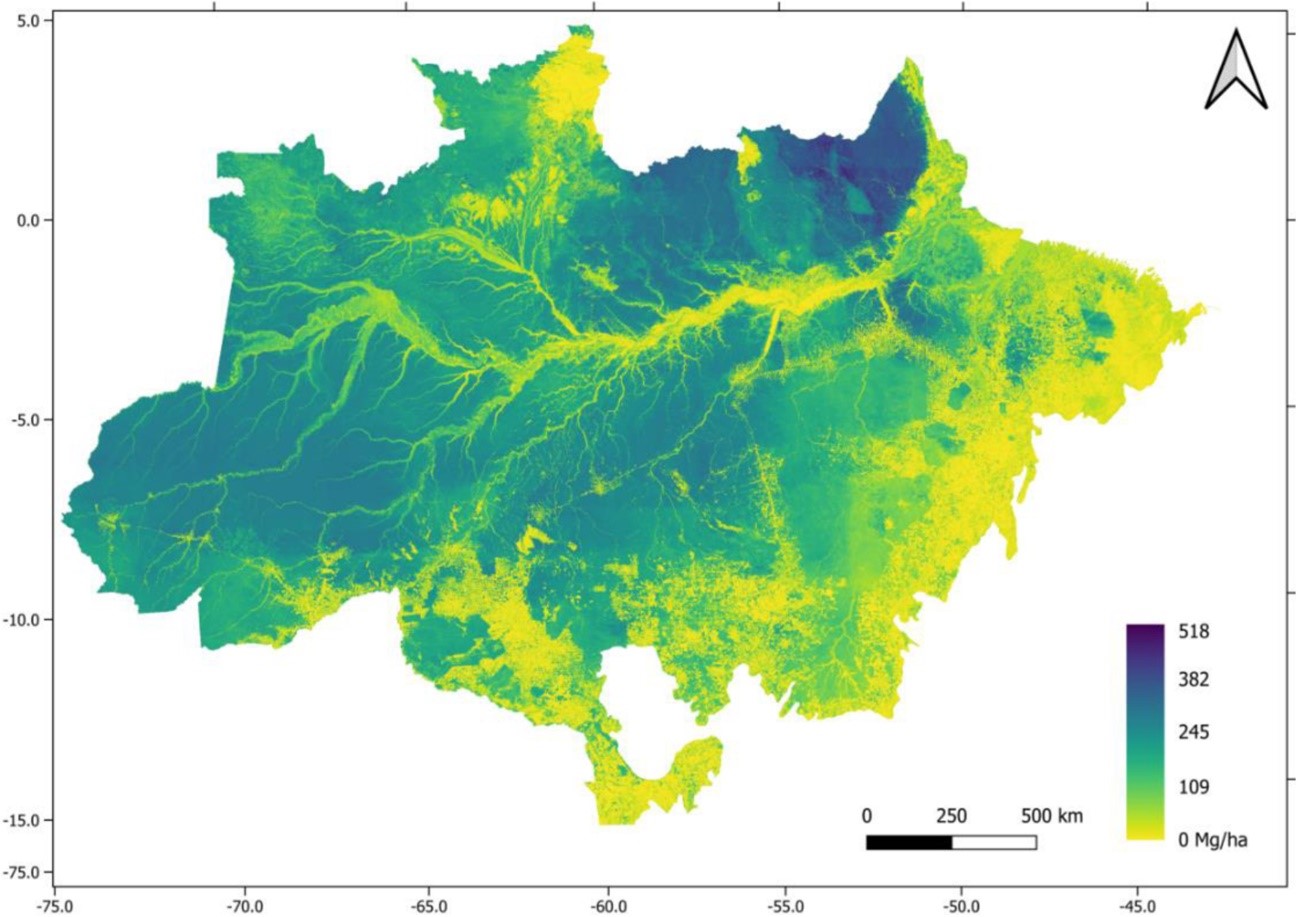
Distribution of above-ground biomass in the Amazon in metric tons per hectare. Riparian vegetation along watercourses can be seen to correspond to lower biomass density (image: Jean Pierre Ometto et al./Scientific Data)
Published on 12/18/2023
By José Tadeu Arantes | Agência FAPESP – Publication of a new map showing all the above-ground biomass in the Brazilian Amazon is good news in the context of the severe crisis afflicting the world’s largest contiguous tropical rainforest. Using airborne laser scanning and satellite imagery calibrated by field forest inventories and integrated by heavy-duty computer processing and machine learning, the map reflects the world’s largest survey of tropical forest biomass ever conducted.
Results of the study are reported in an article published in Scientific Data, a Springer Nature journal. The study was supported by FAPESP and the Amazon Fund.
“We estimated Amazon Rainforest total biomass on the basis of surveys that mapped 3,600 square kilometers in transects [transverse sections cutting through the area, along which standardized measurements were made] distributed across all categories of vegetation in the region. The results showed an average of 174 metric tons of biomass per hectare and a maximum of 518 tons per hectare,” said Jean Ometto, first author of the article. Ometto is a senior researcher at Brazil’s National Space Research Institute (INPE), and a member of the steering committee for FAPESP’s Research Program on Global Climate Change (RPGCC).
The main survey deployed airborne laser scanning in two consecutive campaigns (2016-17 and 2017-18), collecting data from 901 transects in all parts of the forest. Each transect corresponded to at least 375 hectares and was 12.5 km long by 300 m wide. The main survey instrument was a LIDAR (light detection and ranging) sensor on board a low-flying Cessna aircraft, emitting eight laser pulses per square meter on average. Above-ground biomass was estimated in kg, based on tree diameter at breast height, total height, and wood density.
“The numbers obtained in these 901 transects were integrated with data from an instrument called PALSAR [Phased Array L-band Synthetic Aperture Radar] on the ALOS [Advanced Land Observing Satellite]; vegetation indices obtained from the satellite-based sensor MODIS [Moderate-Resolution Imaging Spectroradiometer]; and precipitation data from TRMM [Tropical Rainfall Measuring Mission]. The results were extrapolated for the entire region. Mathematical treatment enabled us to estimate the biomass content of the standing forest with satisfactory precision as amounting to about 75 billion tons,” Ometto said, pointing out that this is above-ground biomass and does not include tree roots.
The total amount of biomass in the Amazon must be smaller now, given the significant deforestation that occurred in the period 2019-22. Biomass losses and corresponding carbon dioxide emissions in deforested areas can be calculated by cross-referencing the map with data from INPE’s Deforestation Satellite Monitoring Service (PRODES).
“We didn’t set out to create a static map but to produce a time series. If we repeat the survey in one or two years’ time, we’ll find out whether biomass is being gained or lost,” Ometto said.
At a time of strong warnings that the Amazon could be close to a tipping point at which it ceases to be a carbon sink and becomes a net emitter of carbon, and when its biomass risks being degraded into a different type of forest structure, the map provides key information to support decisions on planning, conservation and sustainable management.
In addition, the surveys produced several highly interesting discoveries, including pre-Columbian geoglyphs showing that the Amazon was relatively densely populated in the past. They also confirmed that the tallest tree in the forest is a majestic Dinizia excelsa (Angelim vermelho in Portuguese), whose canopy towers 88.5 m above the forest floor.
The article “A biomass map of the Brazilian Amazon from multisource remote sensing” is at: www.nature.com/articles/s41597-023-02575-4.
Source: https://agencia.fapesp.br/50515
